
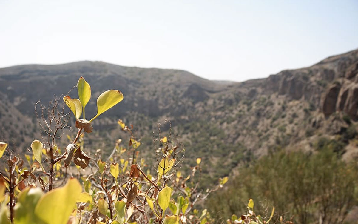
Only a short distance from Las Palmas de Gran Canaria, the Caldera de Bandama offers the unusual experience of walking down into one of the island’s most distinctive volcanic landscapes. The route combines volcanic terrain, historical remains, native vegetation and a final climb that is more demanding than the relatively short distance might suggest.
At First Minute Excursions and Last Minute Transfer, we believe places like Bandama are best understood with practical information and a responsible approach: knowing where to walk, how much time to allow and how to enjoy a protected natural area without damaging it.
Caldera de Bandama: where does the trail begin?
The usual access to the path descending into the crater is near Casas de la Caldera, beside the GC-802 road.
The first part of the descent includes an improved surface before giving way to volcanic soil and loose lapilli. The marked route passes the Cornical viewpoint and gradually leads towards the historic buildings on the crater floor.
The descent is not technically difficult, but the loose volcanic surface requires attention, particularly after wet weather.
At the bottom, walkers can see evidence of former agricultural and wine-producing activity, including old buildings, threshing areas and a wine press. Several paths explore parts of the crater floor before the main route returns uphill.
The ascent is where most visitors will notice the physical effort.
Distance, duration and actual difficulty
The route through the Caldera de Bandama can vary slightly depending on the paths included, which explains why different distances and walking times appear in guides.
Official tourism information places the main itinerary at approximately 3.4 to 4.2 kilometres, with an estimated duration of around 1 hour 45 minutes to 2 hours 30 minutes.
Although the route is often classified as low difficulty, that description needs some context. The return climb and loose volcanic ground are the main challenges, with gradients of around 20% on part of the ascent.
Regular walkers should generally find the route manageable, while people who are not used to hiking should allow extra time and take the climb steadily.
Shoes with good grip are strongly preferable to sandals or smooth-soled footwear.
What is at the bottom of the crater?
Descending inside Bandama gives a completely different perspective from simply looking into it from above.
The depression is around 216 metres deep and approximately one kilometre across. As the trail descends, the volcanic walls begin to dominate the landscape and the scale of the geological formation becomes much easier to appreciate.
The crater floor combines geology, vegetation and traces of human occupation. Historically, this area was linked to agriculture and particularly to vine cultivation.
The Bandama name is associated with Daniel Van Damme, a Flemish merchant connected with vineyards in the area during the 16th century.
Native and endemic vegetation
Inside the Caldera de Bandama, vegetation changes according to orientation, moisture and the characteristics of the volcanic soil.
Wild olive, mastic, euphorbia species and veroles can be seen in the wider landscape. One particularly interesting plant is the white tajinaste, Echium decaisnei, a Canary Islands endemic species.
The botanical value of the route is also a reminder that this is not an open recreational space where anything can be collected.
Visitors should remain on existing paths and must not remove plants, stones or other natural elements from the protected area.
Taking photographs rather than souvenirs from the landscape is the much better option.
Parking and responsible access
Casas de la Caldera should not be treated as a large tourist car park capable of absorbing unlimited numbers of vehicles.
Anyone arriving by car should use only places where parking is permitted and where the vehicle does not obstruct roads, residents’ access or pedestrian movement.
A shorter walk is never worth creating an unsafe parking situation.
Public transport also serves the Bandama area and may be worth considering depending on where the journey begins.
Visitor pressure has become an increasingly important issue at several natural attractions on Gran Canaria. For that reason, arriving outside the busiest periods and being prepared to change plans if parking or access conditions are poor is a sensible approach.
The same principle applies to other small and vulnerable locations on the island, as we explain in our guide to the Barranco de las Vacas and its access and parking issues.
Caldera de Bandama or Pico de Bandama?
The crater and Pico de Bandama belong to the same volcanic complex, but they are not the same place.
The Pico provides a high viewpoint over the surrounding landscape, while the hiking trail allows visitors to experience the crater from within.
Combining both perspectives gives a much clearer impression of Bandama’s scale and volcanic structure.
Travellers who particularly enjoy panoramic landscapes can also explore our selection of viewpoints in Gran Canaria.
Before setting off
This is not a high-mountain expedition, but basic preparation still matters.
Carry water, use sun protection, wear appropriate footwear and check the weather forecast. On very hot days, the exposed terrain can make the walk much less comfortable.
Stay on marked paths, keep noise to a minimum and take all rubbish away with you. The best visit is one that leaves virtually no trace behind.
It is also sensible to check local signs and any temporary access notices before beginning the walk. Protected natural areas can be subject to short-term restrictions or conservation measures when conditions require them.

Leave A Comment